Tony Chang lead a new paper, published in the journal Remote Sensing, that used a convolutional neural network approach to estimate forest structure in California.
[The paper is available here.]
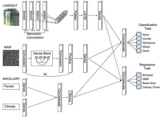
More consistent and current estimates of forest land cover type and forest structural metrics are needed to guide national policies on forest management, carbon sequestration, and ecosystem health. In recent years, the increased availability of high-resolution (<30 m) imagery and advancements in machine learning algorithms have opened up a new opportunity to fuse multiple datasets of varying spatial, spectral, and temporal resolutions. Here, we present a new model, based on a deep learning architecture, that performs both classification and regression concurrently, thereby consolidating what was previously several independent tasks and models into one stream. The model, a multi-task recurrent convolutional neural network that we call the Chimera, integrates varying resolution, freely available aerial and satellite imagery, as well as relevant environmental factors (e.g., climate, terrain) to simultaneously classify five forest cover types (‘conifer’, ‘deciduous’, ‘mixed’, ‘dead’, ‘none’ (non-forest)) and to estimate four continuous forest structure metrics (above ground biomass, quadratic mean diameter, basal area, canopy cover). We demonstrate the performance of our approach by training an ensemble of Chimera models on 9967 georeferenced (true locations) Forest Inventory and Analysis field plots from the USDA Forest Service within California and Nevada. Comparative analysis of the Chimera ensemble versus support vector machine and random forest approaches demonstrates increased performance over both methods. Future implementations of the Chimera ensemble on a distributed computing platform could provide continuous, annual estimates of forest structure for other forested landscapes at regional or national scales.