To stem the global impacts of climate change and biodiversity loss, leading scientists are calling for swift, substantial increases to the amount of land currently conserved.
To stem the global impacts of climate change and biodiversity loss, leading scientists are calling for swift, substantial increases to the amount of land currently conserved. This call has led to ambitious new targets like the Biden administration’s commitment to conserving 30% of lands in the United States by 2030. Achieving this target in the US will require protecting millions of acres of public lands managed by the Bureau of Land Management (BLM) and the US Forest Service (USFS). However, prioritizing which acres to protect remains a considerable challenge because of multiple land-use objectives, the diversity of ecological benefits and services a given place may afford (e.g., wildlife habitat, carbon storage), and trade-offs between those benefits.
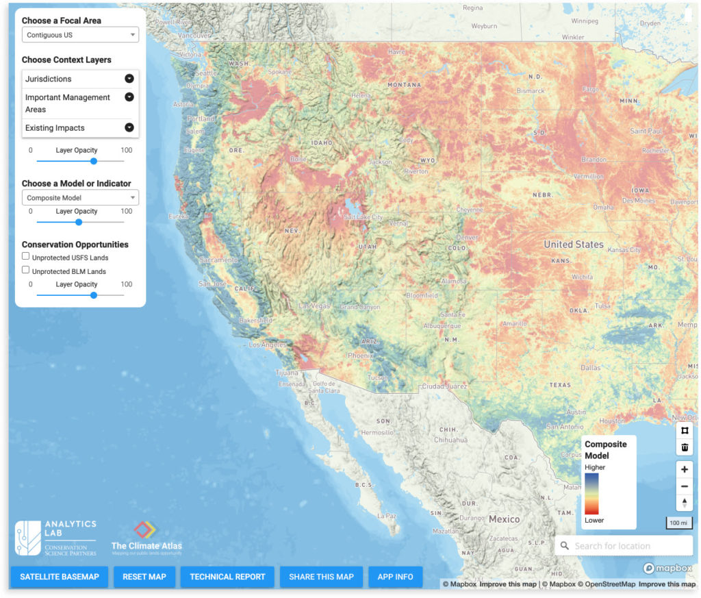
Conservation Science Partners is excited to announce The Climate Atlas, a collaborative project designed to help to resolve this prioritization challenge. The Climate Atlas is a first-of-its-kind, publicly accessible online tool for simultaneously mapping the climate and conservation values of all US lands, focusing particular attention on the millions of acres of conservation opportunities on currently unprotected BLM and USFS lands as well as the Arctic National Wildlife Refuge. The Climate Atlas is a joint project between Conservation Science Partners, Conservation Lands Foundation, WildSpaces Foundation, Audubon Alaska, and Campion Foundation, and was developed in consultation with dozens of federal and NGO partners.
[LINK TO THE PRESS RELEASE]
To develop the tool, our Analytics Lab team integrated the best available spatial data layers on key ecological and environmental indicators–for example, carbon storage, climate stability, imperiled species richness–into a set of indices, with each index providing a coherent, interpretable measure of one of three conservation priorities: preserving biodiversity, mitigating climate change, and quantifying overall conservation value. We then incorporated these indicators and indices into an open-access, web-based tool to allow managers, planners, and decision makers to examine the conservation value of landscapes across the US, along with existing impacts (e.g., oil and gas wells). This interactive web map can be used to explore any area, but it is particularly geared towards unprotected federal lands managed by BLM and USFS, with functionality to quickly generate summary statistics on high value acreage and total carbon storage within any BLM or USFS tract. We anticipate that The Climate Atlas will be useful in guiding conservation across multiple spatial scales, from local initiatives to nationwide planning efforts.