Photo Credit: U.S. FWS
A new publication by Conservation Science Partners, developed in collaboration with The Pew Charitable Trusts and in consultation with the U.S. Forest Service (USFS), identifies locations across the conterminous United States where proactive wildfire management is likely to be effective at reducing wildfire severity and to yield co-benefits for vulnerable human and ecological communities. The paper, published in People and Nature, aims to integrate important but often overlooked factors in the process of prioritizing locations to receive proactive wildfire management: social vulnerability, landscape-scale ecological values, and the provisioning of ecosystem services. CSP also developed an accompanying interactive web map application visualizing the study results.
Although wildfires are a natural part of many ecosystems, they are becoming larger and more dangerous. As a consequence, they present a growing threat to both humans and nature. Yet, traditional prioritizations of areas within which to focus proactive wildfire management – practices such as prescribed fire and mechanical thinning – tend to center on risk to human-built structures. When distributing resources for proactive wildfire management, it will be essential to consider a variety of factors that represent the complex combination of human and ecological community characteristics that can inhibit an area’s ability to recover from wildfire if it were to occur. In this study, social vulnerability is based on variables like low income and high prevalence of respiratory health conditions sensitive to smoke inhalation, while ecological values and services include habitat connectivity and intactness as well as clean drinking water sources.
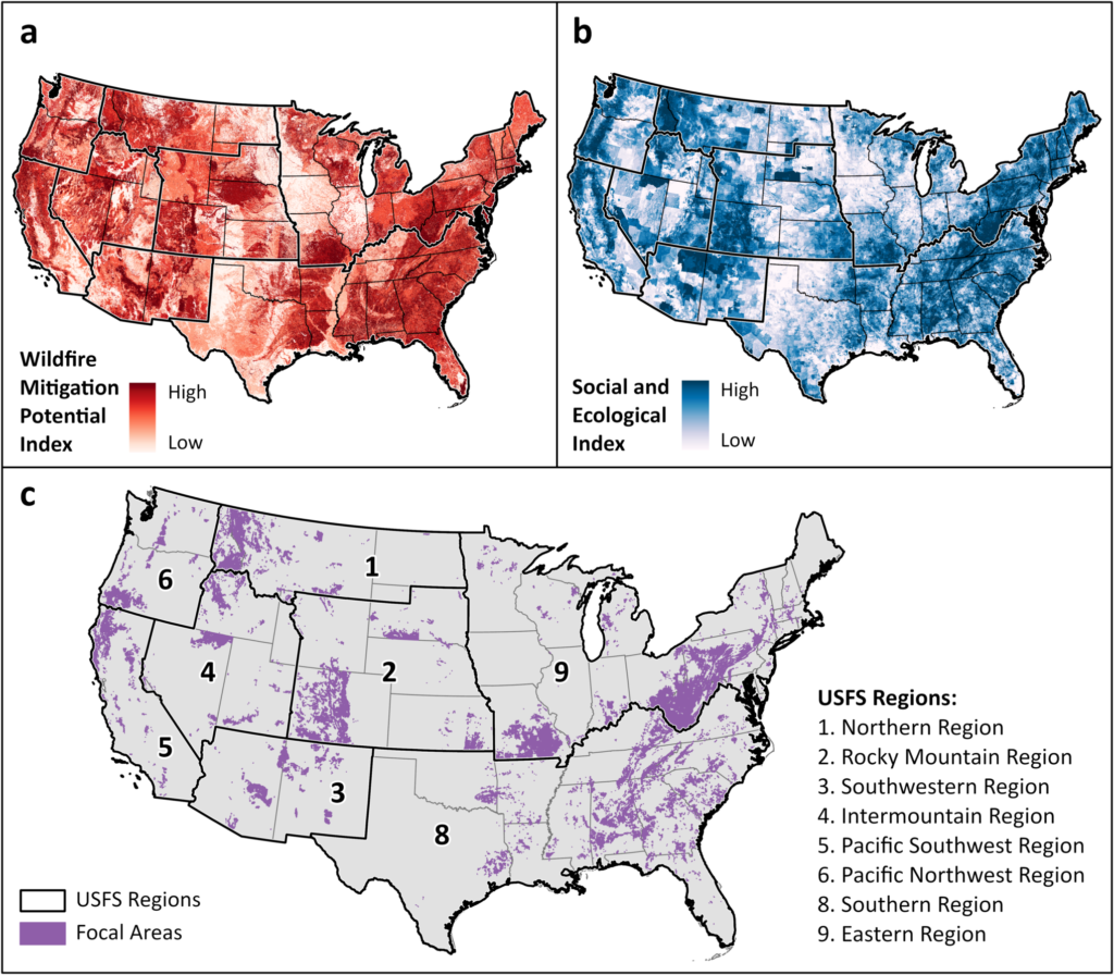
The findings in this paper, specifically the identification of ‘focal areas’ (i.e., locations with high value in terms of social vulnerability, ecosystem services, ecological values, and wildfire risk) that overlap with target areas already identified by the USFS, can inform decisions around where the USFS allocates limited funding to ensure an overall greater ‘bang for their land management buck’ (Fig. 1). These benefits are highlighted in the results, specifically that the inclusion of social vulnerability and ecological considerations substantially increased the representation of vulnerable human communities and ecological values relative to the USFS’ current target areas. This means that by prioritizing wildfire risk mitigation efforts in these areas of overlap, the USFS will likely receive a higher return on their investment from both a human- and nature-minded perspective.

Fig 1. CONUS-wide distribution of (a) the wildfire mitigation potential index (WMPI), (b) the social and ecological index (SEI), and (c) focal areas (areas of overlap between the top 20% of WMPI values and top 20% of SEI values). Both indices were scaled relative to values within each USFS region (regions indicated by bold black lines and listed according to region ID).
The interactive web map application developed alongside this paper presents these results across USFS land within the conterminous US. It will allow land managers and decision makers to explore the spatial distribution of these areas with the greatest return on management investment and ultimately integrate them into existing prioritizations.
CSP’s efforts to inform a balanced approach to proactive wildfire management are also documented here.

