
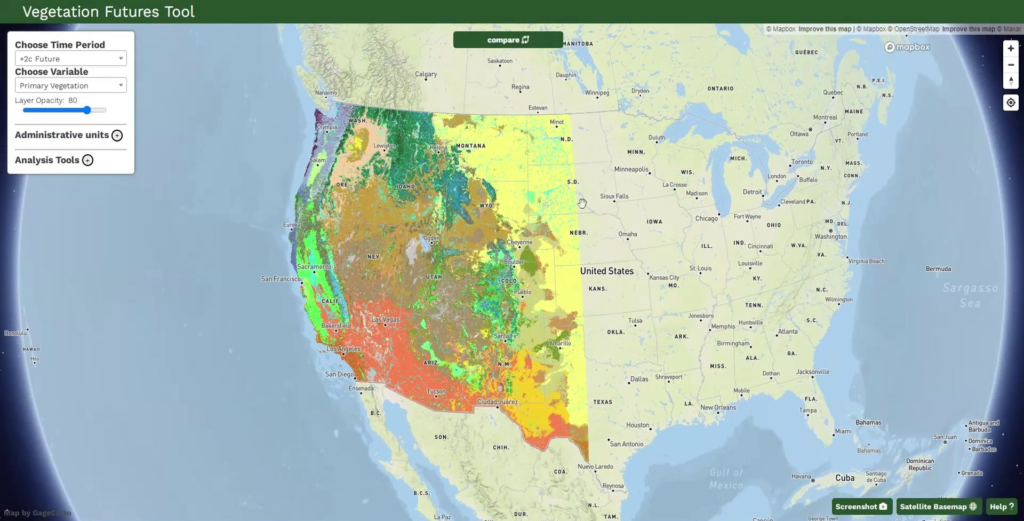
We developed a web-based decision support tool that leverages variability in future vegetation projections to help land managers across the western US explore plausible vegetation futures and guide decisions about where to resist, accept, or direct ecological transformation.
Project Description:
Managing ecosystems in an era of rapid change is inherently challenging—not only because of uncertainty in future climate but also because the ecosystems themselves may plausibly respond in any number of ways. Often, such divergence in projections of future vegetation is viewed as a complicating factor. But in a recent effort funded by the Northwest Climate Adaptation Science Center, we sought to treat divergent trajectories not as a liability but instead as an opportunity to guide management.
Along with colleagues at the University of Montana and USFS Rocky Mountain Research Station, we used climate analogs to project changes in vegetation across the western US under a mid-21st century (+2C) climate scenario. We characterized vulnerability to ecological transformation based on divergence between present-day and future projections. Our results reveal high or very high vulnerability across 29% of the western US—nearly 1-million km², with considerable variability among vegetation groups: 75% of alpine vegetation had high or very high vulnerability compared to just 6% of desert scrub. Forested area is expected to contract by 9%, with subalpine forests declining by 54%. For a given location, the agreement among future projections can be interpreted as how likely a particular vegetation pathway may be—or if it’s ‘anybody’s guess.’
Taken together, the vulnerability metric and projection agreement may support managers in decision-making around ecological transformation—for instance, to resist or direct potential changes in places where vulnerability is low or there are few plausible outcomes. On the other hand, high vulnerability and low agreement may suggest locations where accepting potential changes is simply the best path forward.
To convey this information, we developed an interactive web application that enables users to visualize present-day and future climate variables, vegetation projections, and the vulnerability and agreement metrics, as well as generate a report with maps for a particular area of interest. An associated manuscript is currently in review.
From data set selection to web application functionality, this project was informed by iterative virtual and in-person workshops with 32 partners from the National Park Service, Bureau of Land Management, the Washington State Department of Natural Resources, and elsewhere. We’re excited to have the outputs of this co-produced effort support managers across the western US in grappling with ecological transformation across our lands.

Project Highlights
Leveraging variability in vegetation projections to guide management in a changing world
We developed a web-based decision support tool that leverages variability in future vegetation projections to help land managers across the western US explore plausible vegetation futures and guide decisions about where to resist, accept, or direct ecological transformation.
Read More
Project Highlights
A framework for guiding management decisions for amphibians in an uncertain future
By combining decades of climate and habitat data with remotely sensed imagery and advanced modeling approaches, we have developed tools to help managers in the Southern Rocky Mountain Region protect amphibians from climate-driven habitat loss.
Read More
Project Highlights
Protecting ecologically important areas at risk from oil and gas development
Identifying areas where high oil and gas development potential overlaps with key ecological and wildlife values on federal lands helps make the case for their withdrawal from energy development leases
Read More
Project Highlights
Wildlife crossings as a key tool in the climate adaptation toolbox
We are elevating the important role of wildlife crossings in climate adaptation through science synthesis, connectivity modeling, and convening experts to craft actionable guidance for planning and prioritizing future crossings
Read More
Project Highlights
Monitoring dynamic trends in California biodiversity and habitat to support real-time decision making
Effective wildlife management must track shifting species distributions and community dynamics at the pace of change.
Read More