We are elevating the important role of wildlife crossings in climate adaptation through science synthesis, connectivity modeling, and convening experts to craft actionable guidance for planning and prioritizing future crossings.
Project Description:
A new publication by Conservation Science Partners scientists and collaborators addresses a critical gap surrounding highway wildlife crossings: the need to expressly consider the impacts of climate change. Published in Frontiers in Ecology and the Environment, the paper underscores that wildlife crossings are crucial to reducing wildlife mortality and enhancing habitat connectivity—not to mention ensuring driver safety—and yet rarely is climate change considered in their planning and prioritization. The paper synthesizes the science surrounding wildlife crossings and climate adaptation, offers expert-informed recommendations for incorporating climate considerations, and demonstrates the importance of doing so through a case study in southwestern Colorado, described in depth below. Lessons learned from the Colorado case study were then applied to new work in Nevada, also described below.
The expert-informed recommendations that underpin the Colorado case study emerged from a working group of over a dozen climate, wildlife, and road ecology experts convened in 2022. These experts drafted a consensus statement urging government officials at all levels to consider climate change when planning and prioritizing structures that ensure safe passage for fish and wildlife under and over highways. As appetite grows and funding opportunities emerge for protecting movement corridors and constructing wildlife crossings—for example, through the $350-million Wildlife Crossing Pilot Program funded under the federal Bipartisan Infrastructure Law—there is heightened need and opportunity for developing infrastructure that is sited and designed in ways that account for the impacts of climate change.
Colorado Project Description:
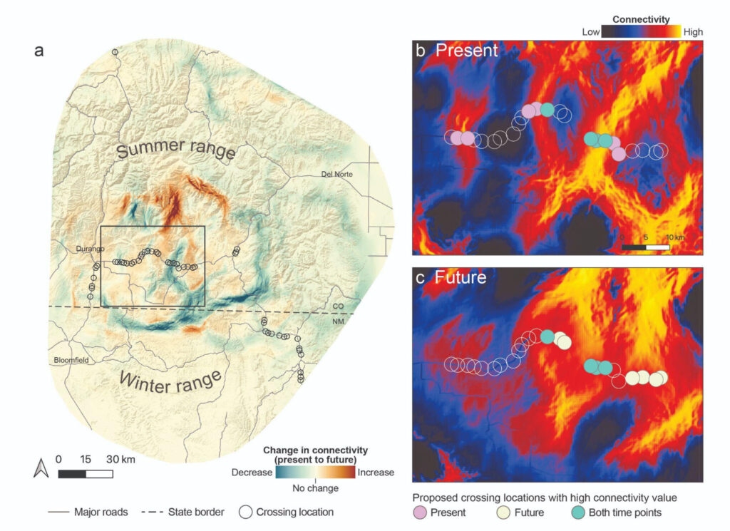
Working with wildlife biologists from the Southern Ute Tribe, CSP scientists sought to put the above recommendations into practice in southwestern Colorado. The wildlife crossings already constructed in this region have proven enormously beneficial to wildlife. How can we ensure that future investments will remain beneficial long into the future? To address this question, CSP used animal movement data and future climate projections to identify potential crossing locations that will support elk migrations both today and into the future. Notably, changes in land-use (e.g., due to sprawl, energy development), vegetation cover (e.g., due to wildfire), and traffic were incorporated into both habitat suitability models and circuit-theory-based connectivity models; to date, there are no other efforts that have integrated such a breadth of crucial information into connectivity models to identify key connectivity areas that will persist under changing conditions. CSP scientists then convened a workshop in Durango, CO with experts from Colorado and New Mexico wildlife and transportation agencies to help refine and increase the utility of the model results for siting new crossing structures.

Change in elk connectivity during migration between present day and future timepoints across the study area (a). Connectivity along a section of Highway 160 (box in a) is shown under present (b) and future (c) conditions. Circles represent potential crossing locations identified in the Western Slope Wildlife Prioritization Study, with filled circles denoting those locations ranking in the top ten for highest connectivity value under present (pink) or future (yellow) conditions or in both present and future (turquoise).
Nevada Project Description:
Informing Nevada’s state-wide connectivity plan and crossing prioritization with climate-driven movements in mind.
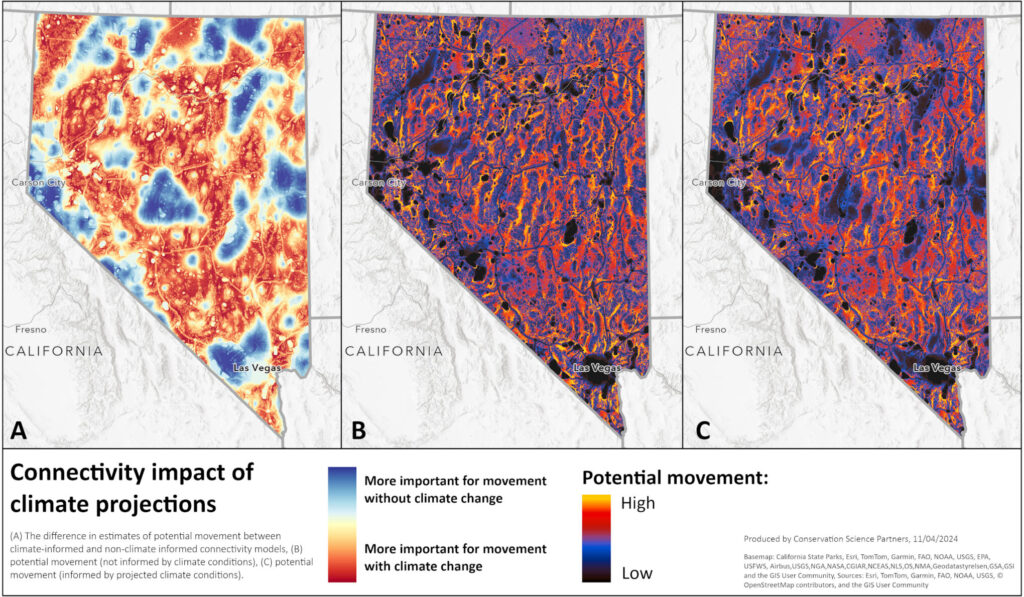
Building upon the species-focused approach developed for southern Colorado, CSP scientists partnered with the Nevada Department of Transportation (NDOT) and Department of Wildlife (NDOW) to identify and prioritize connectivity needs on the state highway system as required under recent state legislation. Specifically, they integrated information on future climate conditions and projected land-use change (e.g., due to energy development, lithium mining, and increased traffic volumes) into state-wide, ecological flow connectivity models that will capture key movement pathways for a wide range of wildlife species. They then used these models to (1) help refine NDOT’s wildlife crossing priorities to ensure that new infrastructure investments both reduce current collision risk and support future climate-driven movements and (2) provide a complement to other connectivity assessments in the state’s wildlife connectivity plan, ensuring that changes in connectivity under future conditions are represented. This work will serve as a transferable model for integrating climate considerations into state-level transportation planning as other states undertake similar prioritization processes.

Core Partners Include:


