


Mapping climate-resilient wildlife connectivity across the San Francisco Bay Area
We developed a novel set of “future-informed” connectivity models that identify areas most likely to sustain high-value wildlife movement today and in the future, designed to support local and regional connectivity conservation and implementation of California’s Room to Roam Act.
Project Description:
The degree to which animals can move across the world’s increasingly fragmented landscapes—what conservation scientists refer to as connectivity—shapes everything from survival today to whether species can track suitable habitat as the climate changes. Long a cornerstone of conservation science and management, connectivity has recently begun to inform the land-use and zoning policies that determine how landscapes are developed. California’s Room to Roam Act (AB 1889), set to take effect in January 2028, reflects this shift, requiring local governments to factor wildlife connectivity into land-use and development planning. Yet turning connectivity science into tools planners can actually use remains a challenge. County-level jurisdictions often lack the spatial data needed to identify which areas matter most for connectivity, both today and as climate change reshapes habitat and movement patterns over time, putting the long-term effectiveness of land-use and conservation decisions at risk.
To help meet this need, the Changing Landscapes Lab partnered with the Wildlife Conservation Network’s California Wildlife Program to develop a suite of contemporary and ‘future-informed’ connectivity models for the San Francisco Bay Area—a region where remaining intact habitat and iconic California wildlife exist alongside intensive, expanding development, making it an ideal proving ground for tools that need to work across a wide range of jurisdictional and landscape contexts. Specifically, we modeled connectivity for four broad wildlife functional groups, defined by their movement capacity, sensitivity to development, and vegetation associations. This approach kept our analysis ecologically grounded while applicable across a wide range of taxa. Maps derived from the connectivity models let us identify areas most likely to support high connectivity for each group both today and under plausible mid-century conditions—what we call high-value “climate-resilient connectivity.” We also layered these maps to reveal where connectivity needs overlap across groups, highlighting places where a single conservation action could benefit multiple species at once.
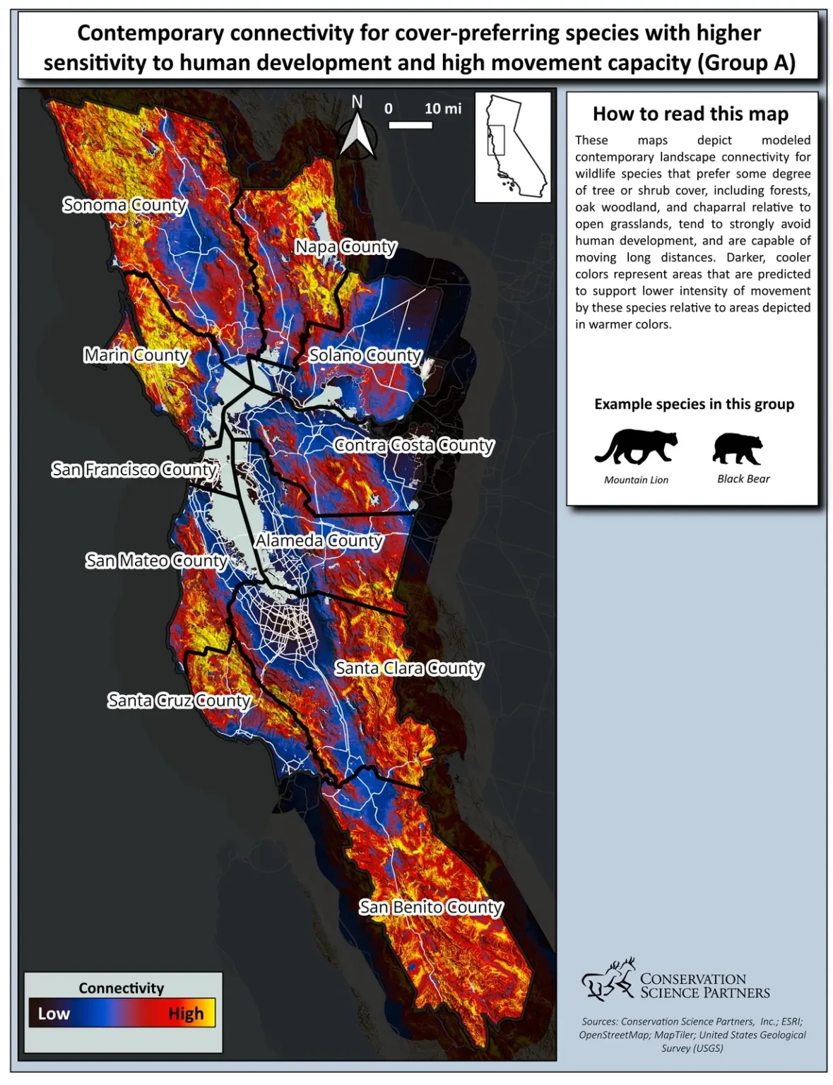
ContinuousA_regionwide_2048
To support broader use of this work, we’re developing a web-based data viewer that will let conservation practitioners and county planners across the region explore these connectivity patterns directly as the provisions of the Room to Roam Act come into effect. We’ve already put these regional results to work at the county level in Napa, where intensive development and agriculture on the valley floor pose a significant barrier to movement for more sensitive wildlife, while the surrounding Mayacamas and Vaca Mountains provide critical climate-resilient movement areas for wide-ranging species. Notably, just 27% of the roughly 243,000 acres we identified as high-value climate-resilient connectivity for one or more species groups in the county fall within currently protected lands, leaving most of Napa’s most valuable connectivity areas open to additional conservation attention. As the county revised its general plan, we submitted a report with these findings and an atlas of maps as public comment, allowing county land-use planners to engage with our results and potentially incorporate them into the data layers that inform their revisions, including as the county works to implement the Room to Roam Act.
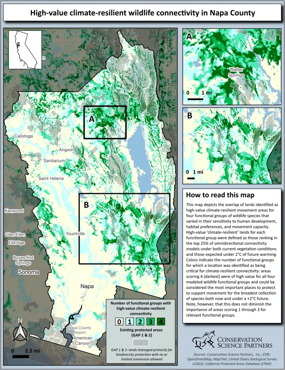

Project Highlights
Leveraging variability in vegetation projections to guide management in a changing world
We developed a web-based decision support tool that leverages variability in future vegetation projections to help land managers across the western US explore plausible vegetation futures and guide decisions about where to resist, accept, or direct ecological transformation.
Read More
Project Highlights
Mapping climate-resilient wildlife connectivity across the San Francisco Bay Area
We developed a novel set of “future-informed” connectivity models that identify areas most likely to sustain high-value wildlife movement today and in the future, designed to support local and regional connectivity conservation and implementation of California’s Room to Roam Act.
Read More
Project Highlights
Protecting ecologically important areas at risk from oil and gas development
Identifying areas where high oil and gas development potential overlaps with key ecological and wildlife values on federal lands helps make the case for their withdrawal from energy development leases
Read More
Project Highlights
Wildlife crossings as a key tool in the climate adaptation toolbox
We are elevating the important role of wildlife crossings in climate adaptation through science synthesis, connectivity modeling, and convening experts to craft actionable guidance for planning and prioritizing future crossings
Read More
Project Highlights
Monitoring dynamic trends in California biodiversity and habitat to support real-time decision making
Effective wildlife management must track shifting species distributions and community dynamics at the pace of change.
Read More